Showing posts with label hiking. Show all posts

Monday, July 14, 2014

Camping at Monadnock State Park

After Andrew and I went for our hike at Mount Monadnock over the Memorial Day weekend, we thought we'd like to go back there to camp. It's not exactly our standard style of camping, mainly, you can drive up to your site, meaning we weren't limited to packing only what we could carry. Don't get me wrong, I love back country camping. I love roughing it, pitching tents, cooking with our little one burner stove, slogging to the top of a mountain to get a breath taking view (if the weather cooperates), I even love wearing a hat all day to hide my unwashed, uncombed hair, and smelling like bug spray, sunscreen, and sweat all at the same time. I really do.

But, doing a stationary, drive-to-your-site camping trip wasn't so bad either. Again, don't get my wrong, it's not like we took advantage of this and brought all kinds of extras we didn't need, heck, we didn't even take showers, but we did have a few perks, like chairs, and a cooler (which contained bacon and sausage). Ultimately, we're still driving our Smart car, so it's not like we can fit much more in it than what our full camping backpacks could carry anyway.
Our beloved Smart car, packed full.
We arrived at Mount Monadnock maybe a half hour before the sun went down on Friday so we had to pitch our tent and set up our beds quickly. Thankfully, our tent is super easy to set up and had everything set before we were out of daylight. We tried to get a fire going, but as we weren't properly supplied (the last 2 bundles of firewood were bought just as we arrived at the entry booth) we didn't have a lot of success. We still poked around our tiny fire until 10:00 before heading to the washrooms (there were flush toilets and running water) and calling it a night.

Personally, I didn't sleep well on Friday. The noise level (both bird and human) wasn't too bad, but I just couldn't fall asleep. Of course I couldn't sleep-in either. The sun came up around 5:00 am, at which point the avian population surrounding the campsite got rather chatty.

Originally, we'd hope to hike for the morning, then rent a canoe or kayak for the afternoon. Note: although the Mount Monadnock website says they have boat rentals--this is a lie! Gilson pond, where the campsite is locate, is rather small anyway, so I'm sure it wouldn't have been a very exciting (or long) paddle. Instead we decided to hike to Dublin Lake, which started out on the same route as the one to the peak of Mount Monadnock. You take the Birchtoft trail up until you hit the Cascade Link then continue on it, rather than turn off it to the summit. As opposed to our first hike, which felt like we were constantly hiking through mountain streams, the terrain was fairly dry. This made for nicer hiking, although it was much hotter and sunnier than our last visit, so it made for a more sweatier trip too.
Part of the Birchtoft trail, nice and dry.
For some reason we thought the Cascade Link, which eventually lead to the Pompelly trail, would be leisurely. I don't know why we thought this. Sure, we didn't go to the peak again, and didn't have to cover the same elevation gain, but it's not like it was an easy stroll on flat ground. We faced several ups and downs, and ultimately we ended up on a much longer hike than we'd intended to take. Good thing we hadn't set our sights on paddling.

I feel that the hiking in New Hampshire is in someways, more challenging than hiking in the Rockies. These mountains are much older, and the elevation is almost half, I think, of what we were at on the Skyline in Jasper, but the trails seem more rugged. We've encounter several instances where we've had to put aside our hiking poles so we can use our hands to climb up a short, but mostly vertical rock face. Similarly, while descending I came to spots where I had to sit on my butt, while extending one leg to reach the next foot hold. Despite all this, it wasn't a bad day hiking, and provided us with some great views of New Hampshire once we got to the top of our trail.
The distant peaks as we hiked across the Cascade Link. There's also a little carin in view, pointing us a long the path.
Looking out over New Hampshire.
One of the hikers we passed mentioned there were wild blueberries on the rail...we couldn't help but stop to pick some.
One of the ridges we walked along on our way to Dublin Lake.
As I mentioned earlier, the hike to Dublin Lake was longer than we'd expected. We weren't working from an extremely detailed map, only the one that was given out at the entry toll both. It's enough to work from, but you have to guesstimate your distances. It was approximately 3 miles (we're in the US, so everything is Imperial, but in Canadian speak, that's 4.8 km) to the Cascade Link/Pompelly connection, then another 3 miles from there to the Lake. We decided to push on down to the Lake for lunch, so it was almost 2:00 pm before we ate. It was worth it when we got there, though. The cool water soothed our tired feet, and the scenery was lovely.
Dublin Lake. We were able to find a small patch not labelled 'No Trespassing' and relax.
The sky on Saturday.
For the walk back to Gilson Pond we opted to go for the more straight forward route along the road. It was still fairly pretty, with interesting houses to look at along the way, but much easier than going back up into the mountains. Plus the route was way shorter, only another 3 miles to get back to where we started, and were we ever glad to get back to our campsite.

Dinner that night took advantage of our being able to bring a cooler/heavier/larger food than normal, involving sausages, peppers, onions, corn on the cob and potatoes. Honestly, I was worried we'd have a dinner fail. First, that we wouldn't be able to get a decent fire going in time and we'd wind of ravenous before the food was ready. Or, that the food would either be under or over cooked. Tinfoil dinners were a common (I can't quite say popular) staple of girl guide camping, and typically you either wound up with raw food, or everything would be burnt. Maybe camping cooking karma caught up with me, as we had an excellent, fulfilling meal. By layering in the food according to how much time I predicted they needed to cook (potatoes: 1 hour; peppers, onions, corn: 30 min; sausages: 5-10 min) everything turned out just right.

Cooking over the fire is hard work--although Andrew did do a lot of poking and adjusting to keep the fire going.
Dinner!
We didn't stay long on Sunday. We felt we'd done quiet enough hiking on Saturday, plus we knew we still had all kinds of chores to take care of when we got home. Still, we enjoyed our time and would definitely consider returning if we were looking for another laid-back camping experience.

Ciao,

Andrea

Monday, May 26, 2014

Hiking: Mount Monadnock

It's Memorial Day here in the US. It was Victoria Day in Canada last weekend, but of course the US doesn't celebrate the birth of British monarchs, so I went to work and waited for this weekend for an extra day off. Honestly, I worked today too, but only my Canadian job, since my Albertan co-workers were in their offices at the University of Alberta.

However, I digress.

Today is Memorial Day, and to take advantage of the three day weekend Andrew and I went hiking on Saturday. Originally I'd hoped to go to the Appalachians, but they're a three hour drive away (much like how the Rockies are three hours away from Edmonton). In around-about way (Googling hikes in Vermont) I discovered another potential hike site: Mount Monadnock, which according to their website is the third most visited mountain in the world. It's located in New Hampshire, but it's only an hour and a half drive away.

As the weekend grew closer we hummed and hawed over whether or not we should go. The forecast was iffy (chance of rain), and the last thing we wanted was to be stuck halfway up the mountain in a downpour. In the end we decided the actual chance of rain was low enough to warrant going, and if it turned out to be cloudy, it would make better conditions for hiking anyway. A blazing sun leads to lots of sunscreen, and sweating.

So, the hike. We parked at Gilson Pond, and started out on the Birchtoft path. From the trailhead, the distance to the summit is 3.4 miles/5.5 kilometers, with a beginning altitude of 1300 feet/396 meters.
The trail started out reasonably easy. After 1.25 hours we'd covered 3 kilometers and were thinking to ourselves, there was no way this trail is going to take us 5-6 hours to complete (what the staff at the check in booth had told us).
The lovely Andrew, out on the trail.
Me, of course. I downed 1.5 liters of water during the course of the hike.
Although all the snow had melted off the mountain, there was still a lot of water on the trails. It made the return trip extra tricky having to be careful not to slip.
A look out point, a little over half way up the mountain.
The last trail crossing pointing us to the summit (or on to another trail).
The summit of Mount Monadnock off in the distance. Once we got close to the tree line we had to follow carins to guide us to the top.
At the top of the mountain, elevation 3,165 feet/965 metres. It took us 2.5 hours (minus 15 minutes for a lunch stop where we each devoured half a loaf of bread).
The view from the top. It was cloudy, but we could see enough around us to make it worthwhile. We stayed for fifteen minutes to rest our feet and refuel, then headed back down.
An example of the steep rock face we had to climb. I thought it was fun to have to scrabble up--albeit challenging.
I would definitely go back if we had the chance, maybe camp there for a night or two and check out some of the other trails, or rent a canoe or kayak.

Ciao,

Andrea

Monday, October 21, 2013

Our continuing exploits in New England: Blue Hills Reservation Area

I've been wanting to go hiking around the New England area since we got here. The drive through Mass is very pretty in the summer (and also in the fall as the leaves turn) with all the trees and the rolling hills of the Appalachians. There's a trail through the Appalachians that cuts across 14 states that I'd love to tackle at least part of, but it's getting a bit late in the year for camping (I know, if we were hard core we could go out in the winter, but I don't think either of us would love the experience).

A (very) little Internet searching yields a plethora of options for places to go for short-term hikes in Mass, both throughout the state and closer to Boston. The hubby didn't want to do any extensive driving to find a location, so I limited my search closer to home. In the end, we dropped my suggestion of the Fells Reservation, and went to Blue Hills, which should have only been a 25 minute drive from our apartment. I think it took us closer to an hour, maybe more.

The initial wrong turn was my fault. I'm still not totally comfortable with driving around Boston. The lane lines, at times, seem arbitrary. Same with the speed limits. And a portion of the I-93 is underground, which I think also changes the driving experience. At any rate, I accidentally got off the interstate in the direction of the airport, which resulted in us getting lost. We don't have a GPS, and like most people, we just use our phones to navigate. On Saturday the mapping feature proved to be slow and caused the hubby to give me more than one erroneous direction. We weren't a happy couple. But, we haven't made it through 9 years of marriage (as of tomorrow) for nothing. After we ended up almost back to our apartment, I pulled over, Andrew took the driver's seat and on the third attempt we made it out to the Blue Hills Reservation.

Saturday was beautiful. Sunny, a very comfortable air temperature (maybe 18 or 20C). We found a place to park shortly after reaching the reservation and headed off. We hiked for a little over 2 hours, covering somewhere in the neighborhood of 8 kilometers (my phone battery drained before we got back to the car). The trails were a mix of flat, easy walking with a few roots, to the Skyline trail, which had lots of rocks, and several reasonably steep (for not being in the mountains) hills to ascend and descend.
A shot of one of the easy strolling trails. The mix of green, orange and red leaves was very pretty.
A brook we passed as we hiked.
After we finished our lunch, we went up a steep, rocky path to an observation tower. It was very popular, probably helped by the excellent view.
A shot of Boston from the observation tower.
My ruggedly handsome hubby, when we paused momentarily on our way back from the observation tower, along the Skyline trail.
Nothing like the challenge of the Jasper Park Skyline trial, the one in Blue Hills was still very pretty, and the rocks did make some of the descents a little tricky.
Next time, on our continuing exploits in New England, I'll write about what was hopefully my last visit to the RMV.

Ciao,

Andrea

Monday, September 5, 2011

Juan de Fuca trail: hiking the west coast of Vancouver Island

From August 24th to 27th, Andrew and I traversed the Juan de Fuca trail, a 47-kilometre hike along the west coast of Vancouver Island. The trail starts at China Beach (about an hour's drive from Victoria) and ends at Botanical Beach (2.5 km from Port Renfrew). There are a number of camping sites along the way, several on beaches, and you can more-or-less evenly stretch out your hike over several days in order to complete the trail. If you're not the hiking-camping sort, you can also just visit one of the sites (although you'll still have to do some marginal amount of hiking to get there), park your stuff there and go out for short day trips, or just hang out on the beach. We opted to take 4 days, and 3 nights, which I think was about right, although Andrew keeps saying it would have been better over 5 days, but I disagree. I'm generally not the sit around and do nothing type, so I think covering shorter distances each day would have made for boring afternoons (we have to carry everything we take with us, so it's not like we could have loaded up on books and games).

Anyways...the hike. When we got back people asked if we enjoyed the hike, or if we had a good time--I find this a difficult question to answer. Was the scenery beautiful? Yes. Was it awesome to camp by the ocean? Yes. Did we run into any aggressive wild life like bears or cougars? No. Did we have to climb enormous hills, just to go back down them and repeat 4-5 times in one day? Yes. Did we slog through mud (ankle deep at times)? Yes. Did I enjoy all aspects of this? No, not exactly, but would I do it again? Yes, without a doubt. I want to do the 75-km West Coast Trail next year, where Parks Canada requires you to take an 1.5 hour orientation session before you can enter the trail. So why, if I can't say I exactly enjoyed myself would I want to do something like this again? Because, as I repeated to myself several times while hiking up and down those hills: I choose to do this not because it is easy, but because it is hard (yes, that's what JFK said about getting to the moon). Also, it appeals to my sense of adventure.

We spent the morning of the 24th running around picking up things we still needed, such as a stove (which we had to leave at the Edmonton Airport--see lesson learned No. 1), pants and gaiters for Andrew, bear spray, etc. Then we also decided to pick up new poi (again, see lesson No. 1), which meant we didn't get to the China Beach parking lot until almost 2:00 pm. Thankfully, the beginning part of the trail isn't too challenging, so we were able to reach our first campsite by around 5:30 pm. We set up our tent, pulled out our food and settled in for the night. There's tons of drift wood on the beaches, which make for reasonably comfy chairs--a good thing, since there weren't any actual picnic tables (which there were on the Jasper Skyline). We had to eat off our knees, but we didn't mind since dinner was delicious (quinoa salad, with dried fruit and bacon). We tried to get a campfire going as well, but the wood was too damp and even dousing it with a little kerosene didn't result in a steady blaze.
Me, right at the beginning of the trail, the first suspension bridge we approached.
Also near the beginning of the trail, one of the first log-steps/ladders that we encountered.
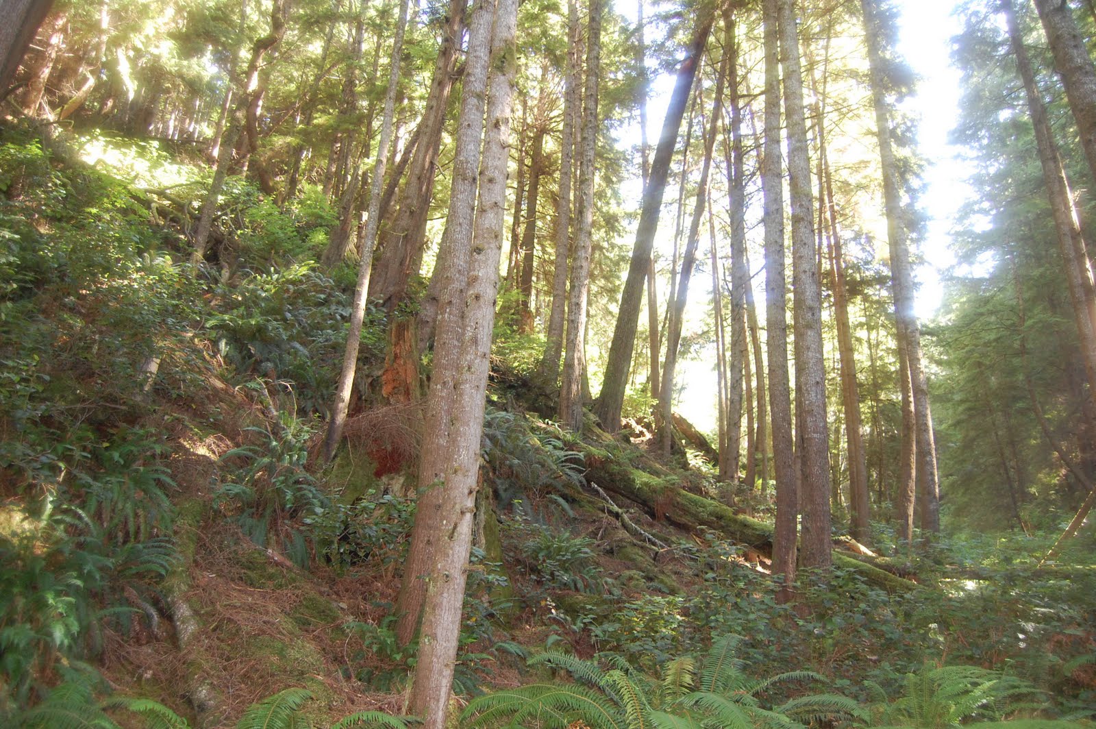
An example of some of the beautiful scenery we viewed on the first day of our hike.
Seagulls hanging out at Chin Beach, the first site we stayed at, approximately 9 km into the hike.
We had great weather for pretty much the entire hike. It was misty most mornings, as can be seen below, but cleared everyday for the afternoon. Thankfully, most of the trail winds through the forest so we were never fully exposed to the sun; therefore I never needed sunscreen, and we also rarely needed bug spray--which was kind of nice. During the second day we covered the most difficult territory. At least four or five major climbs (I don't know the altitude gained, but it was pretty significant) were trekked and it took us 5 hours to complete 12 km. When we got to the beach at 3:00 pm we were worn out. Plus, that day my pack was really bothering me. I felt bad about taking less than Andrew (I get all the food, but he gets the tent, the cookware and many other bits and pieces) and had taken a couple of extra pieces of equipment leaving my shoulders and hips quite sore.

At Bear Beach (21 km into the trail) we soaked our feet in the icy water of the Pacific--it felt great despite the cold. We set up at an awesome site where the tent was enclosed with tree which was connected by a short path to a sort of 'living room' set up with large pieces of driftwood centred around a fire pit. We sat on the logs for almost an hour just watching the waves before we made dinner. This night we were easily able to get a fire going, a relief since it was colder than our first. It also got very misty and from our spot we couldn't quite tell if it was raining or just really foggy as we were sitting under tree cover. We ended up going to bed early. It was wet-ish, and cool, and we decided we were going to try for a longer hike on our third day and would therefore need to get up earlier.
The morning of our second day, before we'd managed to get packed up on Chin Beach.
An example of the scenery on the second day. There were lots of ups and downs this day.
The ocean at our second stop, Bear Beach, 21 km into the trail.
Our third day was a bit hectic. We'd planned to hike 12 km to the Little Kutchie campsite at the 33 km mark, which would have left us 14 km on our last day, plus a 2.5 km trek into Port Renfrew where we would catch a shuttle back to our car. Andrew was worried that we'd have to push too hard to make the 5:00 pm pick up time (the bus only ran once a day), so we agreed to carry on to Payzant Creek located at the 40 km mark. On the blessing side, once we got passed Sombrio Beach, the terrain eased out--a bit. Actually there's a lengthy section before the beach (probably at least a kilometre long) where the path is completely flat. It looked like it might have been some kind of access road. Andrew and I were able to walk side-by-side; however, after that short oasis, the ups and downs returned, although there were fewer and not as drastic, and it got really muddy. Thankfully I opted to wear my gaiters that morning (due to the weird mist the night before), so it helped keep my pant legs clean and dry.

I was exhausted by the time we reach Payzant. The last 3 km (we had a break at 37 km, unfortunately the spot was only a parking lot, not a campsite) were a blurr and it was pretty much just determination that kept me going. It took us 8 hours to cover 19 km, reaching our destination around 6:00 pm. The mud probably slowed us down a bit (pausing to look for ways around, instead of through it) and it left my feet really damp and unpleasant by the time we reached our site. I basically had the start of 'trench foot' developing and would have been in serious trouble if I hadn't been able to let my skin air-dry. Fortunately it was fairly warm at the forest campsite, so I was able to sit and make dinner without wearing socks, which helped immensely. My feet were more-or-less okay (aside from a bit of blistering on my heels) the next morning.
Sun shining through the trees on the morning of our third day.

One of the log bridges we crossed. This one had no hand rail, and hadn't been evened out on top.

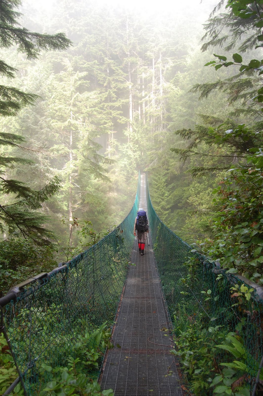
The really big suspension bridge we crossed leading up to Sombrio Beach on our third day.

Another example of the great scenery to be had along the trail.

The Payzant Creek, the location of our third and final campsite 40 km into the hike.
We took our time pulling ourselves together on our last morning. We had a mere 7 km to get to Botanical Beach, the end of the trail, and another 2.5 km to Port Renfrew--the whole point of slogging through the mud the day before. I think by the time we'd had breakfast, cleaned up, and packed up, it was 9:30 am. This section of the trail was considered the easiest, which was a relief, although still quite muddy. We crossed a number of hikers in the opposite direction. Some out for just day hikes, some starting the full trail. A little after noon we reached Botanical Beach, by which point the sun was coming out. We sat on a log and had lunch--I had to put on sunscreen for the first time the entire hike (as it was the first time I actually sat in the sun)--and dipped out toes in the ocean again. Some time after 1:00 pm we agreed we ought to carry on and head into Port Renfrew.

The final 2.5 km was a breeze--along a paved road with only a couple of gentle hills. We probably could have attempted to hitchhike, but I figured we could manage the last bit on our own. It only took us 40 minutes to reach the town (village?), so we probably could have stuck to our original plans after all. We took advantage of our extra time before the shuttle arrived to relax at the Port Renfrew Hotel Pub. It was the prefect treat after 4 days of eating off our knees out of doors. The beer was good and cold, while the food was hot and tasty. We demolished a giant plate of nachos, then we each had a entree as well. We had plenty of time to hit the washroom, pay, and get to the shuttle pick up on time.
The scenery at Tom Baird Creek, just a km or two away from Botanical Beach. We sat and had a quick rejuvenating break before finishing off the trail.
Me and Andrew at Botanical Beach. We sat for an hour, had lunch, stuck our feet in the Ocean, relaxed before finishing the last km of the trail.
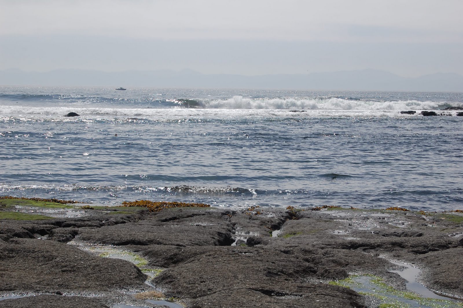
The ocean at Botanical Beach.

The pub at Port Renfew. Delicious!
Notes about the Juan de Fuca Trail:

1) There are covered outhouses at all of the campsites, which include toilet paper.

2) There are also food cashes (heavy metal boxes with giant clips to keep them closed) at every campsite, usually near the outhouse.

3) There are creeks near every campsite, so there's a source of water (once filtered) for drinking/cooking.

4) It was extremely muddy when we were there, so gaiters are a good idea.

Lessons learned:

1) Airlines do not permit camp stoves even as checked luggage, even if you're not packing fuel. We had to purchase a new stove at the MEC in Victoria.

2) 19 km really is too much to hike in one day (for us at least) while carrying packs and going over hilly, muddy terrain. We ran into this problem last year as well, but the lesson clearly didn't stick.

3) Camel packs are way better for hydration than water bottles. You don't have to stop and unscrew a lid to drink, encouraging more water intake; however, when you're sweating rivers, it's hard to keep properly hydrated no matter what.

4) I really shouldn't feel bad about carrying less than Andrew. At least one of the figures I've seen suggests that women should only be carrying about a quarter of their body weight, and men a third. Andrew weights more than me, and is a man, therefore he should carry more.

Ciao,

Andrea

Saturday, March 20, 2010

A brief getaway to the island, Elk Island, that is

For several weeks (nay months?) I've been feeling the need to get out of Edmonton. It's not a need to go far, or see exotic things, just a need to get away from my everyday environment. Unfortunately, living in Edmonton is nothing like living in Southwestern Ontario. If I were in Ontario, I could get to a handful of mid-to-large sized cities where I know someone within about 1.5 hours of driving. In Edmonton...well there's pretty much just Edmonton. I suppose I could go to Red Deer (1.5 hours south) but what would I do there? I have no idea. It takes at least 3 hours to get to Calgary, 3 to get to Jasper and more to get to Banff or Lake Louise. In my mind, these are not really day trips. Albertans seem to do it, and I have once done so myself (drive down to Calgary and back), but as far as I'm concerned it's a lot of driving in one day and not worth it. To make matters worse, Andrew's studying for his PhD candidacy right now. This basically means he has no free time until after it's over. That leaves me without a travelling partner, or at least one that I can immediately talk over my plans with and head off.

Yesterday morning I was wondering what I was going to do with myself; homework and other school commitments are winding down and I'm not feeling pressured to spend all day chained to my computer. After ten minutes or so of humming and hawing I decided that it was time for me to go take a hike (quite literally). I pulled myself together as quickly as I could (layering up, finding mittens and scarves, backpacks, and grabbing our small point and shoot camera) and headed down Highway 16, east of Edmonton to Elk Island. After a slight misdirect while trying to figure out how to reach the entrance of the Wood Bison Trail, I parked at around 10:10 a.m. and headed off. I chose this trail as it is one of the longest (16 km) and the only one that Andrew and I hadn't done yet. Thankfully there was only a light layer of snow on the ground and the sun was out in full force.

Elk. This fellow was very patient with me. I noticed him after I walked passed him, he waited for me to retrace my steps and snap a few photos. I saw a few other elk as I tromped through the woods, but none of the stayed long enough for me to get out my camera.
A single bison. I've seen bison before while at Elk Island, and been much closer to these large animals, but today they didn't seem to want to stay put long enough for me to snap a decent picture.
The trail. I was the first human out since it had last snowed. I saw plenty of animal tracks on the path, but no other shoe prints.
What I assumed is a moose antler (although having never seen a live moose I could be wrong--I don't know how big they should be). No hint of moose though.
Me, just to prove I had actually been there.
Over all I enjoyed the day, although toward the end of the hike I had become quite tired and was focused mostly on reaching the end of the trail. To make matters more frustrating, there were no distance markers after I reached the 3 km sign (I walked the trail backwards and had had signs posting the distance from 16 km down to 3 km) and had no firm idea of how much distance I had left to get back to the car. I would definitely enjoy going out again, although perhaps not the day before our long run as was the case this time. My legs are very much in protest after having carried me over 30 km in the last two days.

Ciao,

Andrea

Sunday, June 7, 2009

Mountain top picnic

Andrew and I took a short camping excursion this weekend. We merged onto the Yellowhead around 3:00 p.m. on Friday afternoon pointed west, and drove until we arrived in Jasper National Park around 3 1/2 hours later (not being native Albertans any drive greater than 1 1/2 hours is long and requires a pit stop). We reached our campsite around 7:00 p.m. and rushed to get our tent up and have some dinner. It had rained much of the day and I was worried about getting soaked as the threatening clouds hadn't dissipated. We were lucky, though. It didn't rain and we had enough time to rush off to the Miette hot springs (15 km up the road from our campsite) and soak in the tub for 1/2 hour. We returned to our camp around 9:30 and built a campfire--unfortunately at this time it started to rain and so we couldn't swing poi.

We woke up on Saturday morning around 7:40 a.m., which surprised me. Given it gets light at 5:00 a.m. these days, I expected to wake up much earlier. We were nice and toasty snuggled up in our sleeping bags, but alas, it is somewhat difficult to hike while wearing a sleeping bag. Both Andrew and I were quite cold as we prepared breakfast (pancakes), washed up and cleaned up our campsite. My toes were stinging by the time we got in the car to head off to the trail we planned to hike. I cranked the heat up to full and directed it on our feet as we drove the 15 km back up to the Miette hot springs. No, we didn't jump back in the pool, but at 11:10 a.m. we began our accent up the Sulphur Ridge Skyline.

Despite the cool temperatures we warmed quickly as we worked our way up this 5 km, trail that climbed 700 m in elevation. The scenery was beautiful, lots of trees and other plant life, plus tons of other mountains. On the way we (not too surpisingly, actually) met mostly non-Canadians. We spoke briefly with a trio of young men from Denmark, Holland and Germany, and came across another group who we suspected were from Switzerland and possibly more Germans. As we climbed closer to the top of the mountain we had to trudge through snow. Quite deep, actually. If you miss stepped you could find yourself knee deep in it. We reached the summit around 12:40 and followed the lead of another group of hikers who had nestled themselves into the side of the mountain protected from the wind. As we lunched we were visited by cute chipmunks who desperately wanted our food--but we didn't give them any.

Shortly after 1:00 p.m. we headed back down the trail. At around the 2.5 km mark we detoured onto a different trail that lead to Fiddle River. The complete trail lead all the way to Mystery Lake (12 km, one way) but we felt we didn't have time to cover the full distance. We were the first ones down this trail in a while. Snow still covered the route and there were no footprints besides ours. We followed the trail for 1/2 hour before we decided we should return to our car. We hope to check the trail out again sometime later this summer. We reached our car around 2:30 p.m., made the necessary bathroom breaks, etc and got on our way back to Edmonton. As we drove the winding road back to the main highway in Jasper, we sighted a bear. It seemed uninterested in those of us who had stopped our cars to check it out.

We reached home by 7:30 p.m. I'm not sure if we'll get out again for another one-nighter trip before our big camping excursion to Lake O'Hara.


Ciao,

Andrea